Friday, July 27, 2012

Nova Scotia Eastern Shore

The ferry ride is a pleasant one. I did not book a cabin. There are few passengers and there is lots of room to stretch out on the furniture. 
The ferry arrives on schedule at 3pm in North Sydney on July 18. After a quick bite to eat at the waterfront we book a room at the same motel we stayed at a few weeks ago. The owner complains about a slow tourist season, they should be fully booked every night but they are not. 
On the road early again on July 19 and we cover the same distance as on the way up and spend another night at the Battery Provincial Park in St. Peters. This time we have enough energy left to visit the tidal lock in the canal that connects the Bras d'Or Lake with the Atlantic Ocean. 

For the next day we decide to travel highway 104 instead of highway 4, which we followed on the way up. Found the surface in better condition and there is a 2 feet wide paved shoulder most of the way. Once we reach the Port Hawkesbury and Port Hastings area, a fierce wind is blowing from the west. This area is a real crapshoot to get through on a bicycle and this headwind does not make it any easier. Once we are on the Canso Causeway we are blown repeatedly onto the roadway by the sidewinds. We don't want to end up as roadkill, safer to walk the rest of the causeway. We are in luck! There is a boat going through the locks and they open the bridge, stopping all traffic.  Now we have lots of room to sway and jump on the bike again.

 Right after crossing the causeway we leave highway 104 and start our trip along the Eastern Shore. This is much nicer! Instead of busy traffic we now see one car every half hour. That night we make camp near Sand Point across from a small lake. Shortly after the tent is up we are approached by a man on an ATV. It is the land owner. He has no problem with us camping on his land but warns us about a black bear that is a frequent visitor to the area. I will keep my air horn close by during the night.
We really like this part of Nova Scotia. The scenery is great and no traffic to speak off. With no major highways nearby it is dead quiet at night.
Next day we make camp at the edge of a graveyard at East New Harbour. That was a first for us and nobody challenged us!
For a few days now I have discomfort in the front of my lower left leg. Must be the muscle or tendon that pulls the foot up. Once we reach Sherbrooke I decide to schedule a rest day for July 23 to give that leg a break. Walking is more painful than biking for some reason. This will also give me time to visit the historic village for which Sherbrooke is well known. Because walking is painful, they allow me to use my bike to go through the village.
All the buildings in this village are on their original foundations and that makes this village a bit unique. There is a blacksmith shop, boatshop, furniture shop, tailor, drugstore, post office and more. The drug store also has a photo studio upstairs. How about lugging this 1860 AGFA camera around?
Judging from the number of billboards I have seen, there is a lot of opposition to proposed open pen fish farming on the Eastern Shore.

With rain in the forecast for the night of July 24 we check into a motel in Sheet Harbour. So glad we did, it poured most of the afternoon and during the night. It was not until 8am next morning that the rain finally stopped.
The last night of our trip we camp wild just off the Musqudoboit trail.
On July 26 we leave highway 7 for highway 207 at Porter's Lake and get onto the Salt Marsh Trail just past Seaforth.

Called Lucy and she started biking from the other direction to meet me.

After a trip that lasted 51 days we meet on the Salt Marsh Trail, have lunch sitting on a bench with a great view of Cole Harbour. Together we bike the last few kilometers to  our home in Colby Village. When we get there, my odometer reading is 3235km.

Sunday, July 15, 2012

Central & Eastern Newfoundland

Nothing better to warm you up than a good hill. Over a distance of about 5km we climb from sea level to 275m after leaving Woody Point on July 8. In the early days this highway was even steeper and was known as "the struggle". Cars could only take this hill in the low gear and you'd better not have to stop! We run into some showers once back on highway 430 but in Deer Lake the sun is out again and it is quite windy. This time the wind is right at our tail and we are moving down the TCH at 25 - 30 km/h. Our target is the junction of the TCH and highway 422 and once we reach it there is a gas station with a restaurant. We don't have to cook tonight! Once again I order pan fried cod. The people at the next table are interested in me and my trip and are quite impressed that I was all the way up the North Western Peninsula. After they paid at the front desk they came back to my table and told me that my meal had been paid for!
The next 2 nights we stayed in motels in South Brook and Badger.


On July 11 I met up with Eileen and Ted again who had to be in Grand Falls that day. We met at Tim Hortons and while waiting there a fellow made me aware of the salmon interpretation center in Grand Falls. There is a restaurant attached to it as well and when Eileen and Ted arrived I suggested that we go there and they were game. After our meal we paid a visit to the center. It is basically a long fish ladder around the power dam in the Exploits River. You can actually see the wild salmon working their way up the ladder and there is one section where there is a large viewing window.  


Fantastic to think that these are wild salmon on their way to their spawning grounds. Looks like Newfoundland still has quite a number of healthy salmon rivers. 

After we said our goodbye's we biked to the Falls View Municipal camp ground in Bishop's Falls. It is an open field and there is no protection against the strong west winds. We had to wait until the wind died down a bit before we could erect our tent. 


On July 12 we camped wild beside the TCH about 20km past Gander at Soulis Brook. Here you can see all our gear in action. Blue fold-up bucket kept upright by a rope from the handlebars, water filter and the tent without the fly. Bob is used as a cooking platform so we won't put the grass on fire. The fly is put on when the sun goes down, otherwise it is too warm.
Not a good sleep, the wind stayed up all night, rattling the fly and lots of trucks rushing by during the night.


When we reach Joey's lookout at Gambo on July 13 it starts to shower. Gambo is Joey Smallwood's birth place, his father David moved here from PEI and started a sawmill.


Here is a view of Gambo and the Fresh Water Bay. 
We bike in light rain for the next hour and by the time we reach the Terra Nova National Park the sun is out again. Ted warned me to expect some steep hills here and he was right. We select the Norman Sound campground and book for 2 nights. Presently it is the morning of July 14 and we are at the store/cafetaria of the campground. Had a great night's sleep. Almost 12 hours in the tent and most of it asleep. We should be well rested for tomorrow!


 East from the Terra Nova National Park the TCH gets busy. The highway is in good shape and has mostly a wide paved shoulder. Exception is a new stretch past Arnold's Cove on a steep incline. Most of the paved shoulder is taken up by a rumble strip leaving a few inches wide path to bike on. I have to stand on the pedals to make it up here and with the traffic rushing by I need all my concentration to keep things straight. This makes biking very stressful and if the whole highway was like this I would have quit a long time ago.


I am behind om my schedule and I won't have time to make it to St. John's. I don't mind, travelling the TCH is not longer any fun. Glad when I reach the junction with the 202 and can leave all the traffic noise behind. Soon we find a good spot for camping near a small lake. There are quite a few travel trailers here from folks who found a nice spot and parked their rig there for the summer. Apparently that is allowed in Newfoundland. I put up my tent right across from a trailer on a grassy field. After a while the owner walks over and informs me that the field floods during a heavy rain. Since there only a few showers in the forecast for tomorrow I will take my chances. Only 50km to Argentia from here where we will board the ferry for Nova Scotia tomorrow.

It is now July 17. I expected the 202 to be a very quiet highway but while packing my stuff cars keeps passing by like a city rush hour! Later we find the reason, there is large processing plant in Long Harbour with a huge parking lot and it is full of cars. Once we are past that things become quiet.


From the 202 we connect to the 100 via the 101. I am surprised how mountainous the Avalon Peninsula is here. The 100 is a breeze, it has a wide paved shoulder and is mostly downhill.
Soon we bike besides the Norh East Arm of Placentia Bay with some great views.
At 1pm we reach the ferry terminal. We first bike around Argentia for a while but it is just an industrial complex and there is nothing to do. So far we have been able to avoid the showers but it looks like they are now on their way. Shortly after we enter the ferry terminal the ferry "Atlantic Vision" arrives from North Sidney. We will be on board when it leaves again just before midnight. It is going to be a long sail, scheduled arrival in NS is 3pm tomorrow!
We did not make it to St. John's but after having done 1925km on the island we can keep our heads high and say that we biked Newfounland!

Sunday, July 8, 2012

North Western Peninsula

Today is July 7, day # 32 of our trip. Since our last blog update, we went all the way up the North Western Peninsula and almost back. Presently we are in Woody Point at Bonne Bay and are just 20km shy of 2000km. At one time after leaving St. Anthony we tried for about one hour to hitch a ride but no luck. With all the gear we need a pick-up truck to take it all and in that hour 3 trucks passed by without stopping. Looking back we are glad not to have gotten a ride, the weather improved and the biking has been great. Driving the same route from the opposite direction makes it look different and you see things you missed the first time.


We camped one night at the community River of Ponds. Lucy and I were there exactly 40 years ago and highway 430 was a gravel road at that time. The campground was a provincial park at that time but has been in private hands since 1997. I had to find the spot where I caught my one and only Atlantic salmon and I am pretty sure I did.


 We took a little side trip to St. Barbe and the terminal of the ferry that goes to Blanc Sablon. We were at the other side 6 years ago during our Labrador bike trip. This kinds of completes the big loop for Bob and me.


After River of Ponds the Long Range Mountains go out of sight and the road hugs the coast most of the time. There are lots of small communities on the way and past Eddies Cove the road turns east to cut across the peninsula direction St. Anthony and the east coast. One night we camped wild about 20km past the Eddies Cove alongside a salmon river. I was laying down in my tent after a hard day's work and heard a vehicle stop and back up. A lot of hollering started and I had to assume that it was directed towards me. Reluctantly I opened my tent and saw two fishermen and their truck full of fishing gear and they had just seen a coyote at the other side of the road and told me that it may be heading for my tent. I thanked them for the warning and would keep an eye on him. After that I went to sleep and never noticed a thing. Yes, what was I supposed to do? Pack up my stuff and move a ways down the road?

We paid a visit to the L'Anse aux Meadows National Historic Site. It is right at the end of highway 436 and is as far north as one can go in Newfoundland.  I quote: "Discovered in 1960, this is the first authenticated Norse site found in North America and could be Leif Ericsson's short lived Vinland camp. Some time about AD 1000 Norse seafarers established a base here from where they explored southwards. The traces of bog iron found - the first known example of iron smelting in the new world - in conjunction with evidence of carpentry suggest that boat repair was an important activity".
Above is one of the buildings that was recreated by Parks Canada from evidence found at the site.


Here is an example of what was left of the camp when it was discovered in 1960.


This is the actual community of L'Anse aux Meadows at the end of highway 436.


 I was wondering about all the wood piles I saw at the side of the road. One of the guides at L'Anse aux Meadows gave me the answer. Local residents can buy a licence for $25 and get assigned a lot where they can cut fire wood for their own use. They cut this in the winter and bring it to the road side using a sleigh pulled by snow mobile.
 There are quite a few gardens at the side of the highway. During construction of the highway the top soil was moved to the side and is now made to good use by the locals.
 We visited St. Anthony and biked right to the end of highway 430 where I took this picture using the selftimer. The spot where I am standing is called Iceberg Alley but unfortunately it was totally fogged in the morning I was there.
 We visited the house of Dr. Wilfred Thomason Grenfell who during his lifetime greatly improved healthcare and with that living conditions for the people living on the Labrador coast and Northern Newfoundland. This got my interest because during the 4 years we lived in Churchill Falls, Labrador, health services were provided by the Grenfell Association.
  When camping at the Three Falls RV Site and campground, about 10km outside St. Anthony, we were at the tent part of the park all by our little selves. While preparing a simple meal I heard some movement behind me. When turning I was looking straight at a young bull moose. I am sure that he knew that I was there but totally ignored me and just grazed away. 
Later he moved to the road and walked right in front of our tent site, totally ignoring me. This was the closest encounter with a bull moose I ever had. Glad that this is not rutting season.
 The weather was much better going back. Salmon season was in full swing. This shot is from the Torrent River. Look at all those fly fishermen trying to hook a salmon. I would have loved to be standing there myself.
 On July 6 I met fellow bikers Rob, Sarah and daughter Cedar from Portland, Maine. They have been on the road since early May and on their travels also were in Cole Harbour and on the Salt Marsh Trail. They are on their way to St. Barbe to take the ferry to Labrador and from there take the Nordic Express (well known to me) to Rimouski and then on the Quebec City where they will meet up with family. They maintain a website at: WWW.CRAZYGUYONABIKE.COM/DOC/BIKETRIP2012

On July 6 we arrived back in Rocky Harbour and decided to change our route a little. Instead of following the  430 all the way, we biked from Rocky Harbour to Norris Point, having to climb a hill of 150m starting at sea level. It was worth it, the view of Bonne Bay and the communities was breath taking. From there we took a water taxi to Woody Point, had to unhook Bob and take all the gear off my bike to get it on the boat. Once at the other side I was getting pretty tired and promised myself that if I would run into a motel at the other side, I would go for it. And about 1km from the terminal I found the Woody Point Motel, complete with a restaurant were they specialize in fresh seafood. Had a great meal of pan fried cod  last night.
When I woke up this morning it was raining and decided to make this a rest day. No WIFI at the motel. I am  now in the Granite Coffee House downtown Woody Point updating the blog. It has a laundromat attached to it and now we have all kinds of clean gear again.
Tomorrow we continue on highway 431 until it meets up with the 430 and then on to Deer Lake and the TCH. Life is good!

Tuesday, June 26, 2012

Newfoundland

Today is June 18, day #13 of our trip and we are biking on "the Rock". There is a low cloud cover but that burns off after a while and we are in full sunshine. Lucy and I were in Newfoundland in 1971 for the first time and I remember this spot from that first trip. 

The sign in those days was warning for winds that could blow a train off the rails but since the train has been long gone, the sign had to be adapted. Hardly any wind today. I love this rugged landscape, it reminds me of Iceland. Not a tree in sight. Our target for today is the Wishingwell campground and according to the guide it opened on May 1 but once we reach it there is a steel cable across the entrance and not a soul in sight. In my book, cyclists are never turned away and we lift up the cable and make our way inside. Next we hang our hammock and go for a nap. My strategy is not to put up the tent right away until I get the feeling that things are going to be all right. In the meantime the owner shows up and as soon as I get out of the hammock he drives over in his pick-up truck and in a hostile way tells me to get lost. I explain that according to the guide he is open and that it is not that easy to pack up and go for the next campsite when travelling by bicycle. He does not give a darn and I have to go. The answer to my question of whatever happened to the Newfoundland hospitality is: "You just had a nap didn't you?" Now I would not stay even if he paid me and we pack up and find a spot near a stream about 2 km further down the road. If you ever go for a camping trip in Newfoundland, please don't stay at the Wishingwell  campground.


I am in daily contact with Lucy and she told me that she had a surprise visit from Eileen and Ted Hillier, friends we have known since our Churchill Falls days and have not seen for 18 years. They live in Bay
d'Espair in Newfoundland. They told Lucy that they are taking the night ferry that arrives in the morning of June 19 in Port aux Basques and would be on the lookout for me. Today is June 19 and day # 14 and I have calculated that they would pass me between 9:00 and 10:00am. At the end of a coffee break when I am ready to mount my bike a black SUV stops at the shoulder of the road and there they are! 

What a nice surprise and so good to see them again. Stupid me forgot to take a picture of this moment. They are on their way to their daughter Patty in Pasadena. I am invited to join them there since I will be near Pasadena tomorrow. It will mean that I have to do an additional 15 km tomorrow for a total of 88 km but I will do my best to be there. Our target for today is the Barachois Pond Provincial park but we reach it early and decide to keep on going. Soon we run into a moose fence and all vegetation between the fences has been stripped and no way to get off the highway to make camp or get to water. We are forced to keep going for another 25 km until the fence ends and now we can start looking for a spot.  


We are having great weather. No rain at all since June 10 and today is June 20, day #15. Just over 60 km to go to Pasadena, should be an early one. Slowly but for sure we have worked our way up to an elevation of 300m and near Corner Brook we get payback for our hard work and drop down over several kilometers to near sea level and enter the Humber River valley. There is a well know downhill ski resort here called Marble Mountain. There is a Tom Hortons at the foot of the mountain, the first one since Port aux Basques. Have to have a little break here!


We work our way through the coastal mountains through the Humber River Valley and soon cycle along beautiful Deer Lake. At around 10:30am we reach the "Welcome to Pasadena" sign and call Patty's house phone.


 Ted drives up to meet me and I follow him to the house where I meet Patty and Eileen. Patty grew up and has 3 daughters of her own now and the oldest is 20!  I am having a delightful time in their company and the day goes by far too quick. There is so much to talk about. Eileen makes Lasagna for supper and we are having a few glasses of Ted's home made wine. Don't have to make camp tonight, I can sleep on the couch in the rec room.

It is like sleeping in for me the morning of June 21, day # 15. At 7:30am I hear some noises upstairs and I get up myself. I am served a hearty Newfoundland breakfast and we say our farewells around 9:30am but not after promising to visit Eileen and Ted in Bay d' Espair in the near future.


At the town of Deer Lake we leave the Trans Canada highway and start travelling highway 430 up the North Western peninsula. Plan is to follow this highway all the way up to the end for 490 km one way. After we reach the end, we will have to come back the same way. If we are offered a ride part of the way on the way back, we won't decline. Cycling this route once is enough! We make camp at a shores of a small lake (or pond as they call it in NFLD).  


On June 22, day # 17 we have to work our way through the Long Range Mountains to get back to the coast. We do a lot of climbing and are soon  rewarded with a fabulous view. Good spot to have a coffee break. While there a delivery van stops and the driver informs me that a black bear crossed the road a little further down the road. A rare occurence in NFLD according to him. I thank him for taking the time to warn me. A bit later I spot evidence of a bear's presence, a garbage can with the lit removed and all garbage draped around it.


We now enter the Gros Morne National Park. Lucy and I were here exactly 40 years ago, highway 430 was a gravel road at that time and the park had just been created and was under development.
Now we are in for a real climb. Once we reach the top, my GPS indicates 332m, the highest elevation so far this trip. After descending, the road hugs the the east arm of Bonne Bay, a real fjord. At one time while cycling I hear a big "puffff" and spot a minky whale. He surfaces several times.


We are getting close to the Gulf of St. Lawrence. I can see fog trying to get into the fjord but the cliffs are holding it back.


We start to see the beauty of the park. There is an actual mountain called Gros Morne. It is the one with the flat rocky top in the picture.There is a hiking trail to this mountain.
After 44 km, well short of the planned 78 km, I call it quits and check in at a private campground in Rockey Harbour. I treat myself to a meal of pan fried cod at the local restaurant but 
it was not as good as the cod in Port aux Basques.


The next day June 23, Day # 18 it is foggy and we can't see the Long Range Mountains. During one of my stops a hare hops in my direction. Instead of running away he is getting closer. Are we under a hare attack? No, he goes around us and disappears in the high grass.


Many viewpoints along the way and we stop at all of them. Here is what is left of the SS Ethie. She ran aground on Dec 11, 1911 and all 92 passengers and crew survived the ordeal.


One of the must sees of the park is the West Brook Pond. This is the land-locked fjord you see on all the promo's of  NFLD and Labrador tourism. It takes a one hour hike to get to a dock where one can take a boat tour of the fjord. The boat tour starts at 1.00pm and needs at least 20 passengers to make it worth their while. Don't want to leave my bike and Bob unattended at the head of the trail. Have to make camp first. Since I am in a National Park, wild camping is not an option and I have to go for the nearest campground.


By the time I reach the Shallow Bay campground I am 23 km past the head of the trail. Decide to stay put for today on the campground and bike back to West Brook Pond tomorrow. Later in the day the fog lifts and we are in full sunshine again. The campground is a part of the National Park and has no serviced sites. But to my surprise it has WiFi available at the shelter/washroom building. The campground is right at the Bay of St Lawrence and has dunes and a sandy beach. My only complaint is that the place is infested with musquitoes.

June 24, day # 19 is another sunshiny day and a great day to visit the Western Brook Pond. By 10am we are on the road and can see the entry of the fjord from quite a distance. We missed it yesterday due to the fog. I am biking with no load, Bob has to stay at the campground. It takes just over one hour to reach the trail head and hide my bike in the bushes and mark the spot on my GPS. I reach the dock at around 11.30 and there is nobody there. 


Across the lake I spot a moose and her calf in the water. You will have to blow up the picture to be able to see them.


I have some time before the start of the boat tour and hike a side trail to the Western Brook and the fjord is always in view. Also use my filter to fill my water bottle from the brook.
By the time I get back to the dock it is 12:45 and I am in for a shock. There are at least 150 people waiting. Will there be room left for me? Yes, fee is $60 and you have to have a park permit. I had purchased a season permit at the visitors center a few days ago. Early bird special for $20.85. Normal fee is $45 for a senior. Enjoying Canada's natural wonders does not come cheap!

The boat tour takes about 2 hours and takes you to right to the start of the fjord. The length of the fjord is about 13 km. Once this fjord was connected with the Bay of St Lawrence but after the glaciers melted the coastal flatland re-bounced and the fjord became land locked. It is now a fresh water lake and the water is as pure as you can get and is 150m deep at places. High cliffs at both sides and several waterfalls spilling from them.
After this fun filled afternoon we still have to bike 23 km back to the campground. On the way back we stop at the town Cows Head and stop at the local restaurant. Guess what! Cod is on special! By the time we get back to our tent it is 8pm.

This nice weather had to come to an end. Today is Monday June 25, Day # 20 and showers started early this morning and lasted most of the morning. Long term outlook does not look good this moment.Taking a rest day today and use it to do some maintenance and to update the blog. Can do this blog work thanks to my notebook that I purchased a year ago in Whitehorse. I am 3 days behind schedule now but that is OK. Will make up somehow by shortening the trip. We have biked 1200 km since leaving home on June 6. All is well.

Monday, June 18, 2012

Nova Scotia and Prince Edward Island


Me and Bob are on another adventure. There are two provinces left on the bucket list, Prince Edward Island (PEI) and Newfoundland (NFLD). In the process we will also cover a good part of Nova Scotia (NS) by bike.

We left home on June 6 under grey skies and cool temperatures. This is the fourth time that we bike the route from home to the New Brunswick border so no surprises here. The first night we camped wild at the Mastodon Ridge near Stewiacke.  While eating a simple meal at the Chinese a light rain started, forcing us to make camp in the wet.

The rain stopped sometime during the night but the next morning the sky was just as grey. The target for day #2 was the Railway Station Inn in Tatamagouche where I met Lucy. This Inn is one of our favourites and our room was located in an original railway caboose converted into a hotel room.  We enjoyed a few beers at the local tavern and a good feed of panfried haddock. Later in the afternoon the sun came out and I was able to dry my tent.

Target for day #3 was the Amherst Shore provincial park but when Bob and I got there the park had not opened for the season yet. Makes you wonder why we have provincial parks at all if they are still closed on June 8. We pushed on to Port Elgin just inside New Brunswick, adding 30km to today's trip, where we made camp in the center of town on a grassy field near the harbour. We selected Port Elgin because there is a small diner there but unfortunately that one was closed as well. Without facilities to clean our pots we selected to eat chili straight out of the can after warming it up in the sun for a while. To make up for this inconvenience we treated ourselves to a can of "Canadian" from the liquor outlet across the street.

On day #4 we had to cross the Conferation Bridge that connects PEI with the mainland. This bridge is 13KM long and bicycles are not allowed to cross this bridge. There is a shuttle service for pedestrians and bicycles. The shuttle is not on a schedule, it goes on demand. When arriving at the foot of the bridge the shuttle happened to be right there to bring a load of golfers to the island. When I told the driver that I needed 15 minutes to take the side bags off my bike and to unhook the trailer he decided to come back for me later. While waiting for the shuttle to arrive it started to spit  and we arrived in PEI in the rain. From tourist information we got a lead on a simple motel just down the road and we stayed the night in the Carlton Motel in Borden.


Next morning on day #5 we picked up the Confederation trail near the motel. This trail is a former railroad bed converted into a multy purpose trail and it goes all across the island. The advantage is that one does not have to deal with other traffic and the grade is never over 1%. The disadvantage when I was travelling the trail was that the surface was soft due to yesterday's rain, giving the impression that one is biking on very soft tires. Also the wet reddish PEI dirt is picked up by the tires, spilling it all over my side bags and trailer. It is another grey day with drizzle off and on but that does not spoil the views of the beautiful PEI countryside. At one time we spot a fox at the side of the trail. The plan was to follow the trail until Hunter River but at the small town of Fredericton we changed to the hard surface of the main highway #2. We soon find out that PEI has some very steep hills as well. The target for today is the Vigeant Residence in Cove Head, about 55KM from the motel. We have been friends with Rosemary and Robert Vigeant since our Churchill Falls days and Leanne just started walking when we first met them. Leanne is now 35. Lucy arrived at the Vigeants the day we left the Railway Station Inn and is waiting for me. I had an early start this morning and will be arriving early. With 10KM to go I called Lucy to expect me around 12am. With about 5KM to go I met another bicyclist going the opposite direction and at closer range I see that it is Rosemary. After I had called she got dressed quickly and jumped on her bike to meet me! What a nice surprise and together we cover the last stretch.

We have very nice visit with the Vigeants. I planned a rest day for day #6 and use that to clean my bike and side bags. We visited one of Rosemary's sisters and picked up her mother, who just turned 92, in Charlttetown. She will join us for supper at R&R.
Rosemary surprised me by announcing that she will join me for day #7 cycling the 85KM from Cove Head to Wood Island where I will take the ferry to Caribou in NS. Robert will pick her up from there by car. She is part of a bike group that almost daily cycles their neighbourhood and four members will join as as well for the first 25KM. We meet at 8am at the house of Sue and Bernard where John (76) and his brother Ewen (78) are waiting as well. I set the pace since I have about 35KG hanging from my bike and will be the slowest. Shortly after 8am the group of 6 is on their way. When we reach Mount Stewart, the turn-around point for four of the group, my front derailler acts up. Looks like the bracket that holds it to the frame became loose and it turned. After this is fixed we say goodbye to our friends and Rosemary, Bob and myself head for the hills. Not an easy route that I selected. Quite a few long steep hills and a head-on wind all the way.

But Rosemary is quite the trooper, took all those hills without complaining and had no trouble at all keeping up with me. She really enjoyed my Crazy Creek chair when taking a rest. Weather was great, full sunshine all the way and warm. It took us a little longer than expected to cover the 85KM and we reached Wood Island at 4:30pm, just when the ferry was leaving. When we drove up to the terminal Robert arrived as well. Perfect timing! Rosemary's bike was tied to the bike rack and we said our goodbye's. The next ferry leaves at 8:00pm and it will be almost dark by the time we get to the other end. I select to stay in Wood Island to take next day's ferry of 6:30am and make camp on a grassy field near the terminal.

Not a good night sleep. Trucks rolling in all night to line up for the early morning crossing and most of them leave their engines idling. Boarding the ferry was uneventful and we are back in NS by 8:00am. Had a meal of bacon and eggs on the ferry. Target for day #8 is Arisaig Point on the Sunrise Trail. Weather is good again but once more I have a headwind. Just 5KM short of our target we run into the Red Roof B&B at McArras Brook. The sign reads "Vacancy" and the place looks very inviting. I learn that the home is modern and solar powered and is two years old. I am greeted by several barking dogs and the Inn keeper ensures me that they are friendly and that he was expecting me. After my reaction of surprise he realizes that I dropped in unexpected and there is another couple of cyclists on the way. No problem, they have a room for me.  I take a quick shower to wash all the sunscreen off me and I am presented with a complimentary beer. That is a first for NS! I can also sign up for dinner with complimentary wine for $15. I don't have to think long over this one! A short time later a Dutch couple arrives with real Dutch looking bikes. They flew in with Iceland Air and only paid 39 euro to ship their bikes. They started in Truro and are following the Sunrise trail and are also planning to bike the Cabbot Trail. Going to bed early. Breakfast will be at 7am, the earliest the Inn keeper was willing to go.  The Dutch couple will have their breakfast at 8:30am, far too late for me!

On the road by 7:30am on day #9. It is now Thursday June 14. Today we plan to bike to the Hyclass Ocean Campground. Lucy and I have been there before and have good memories. The weather could not be any better. Sunny and warm but once again I have a headwind. We arrive in the early afternoon and relax the rest of the day. Macaroni and a can of salmon for dinner.

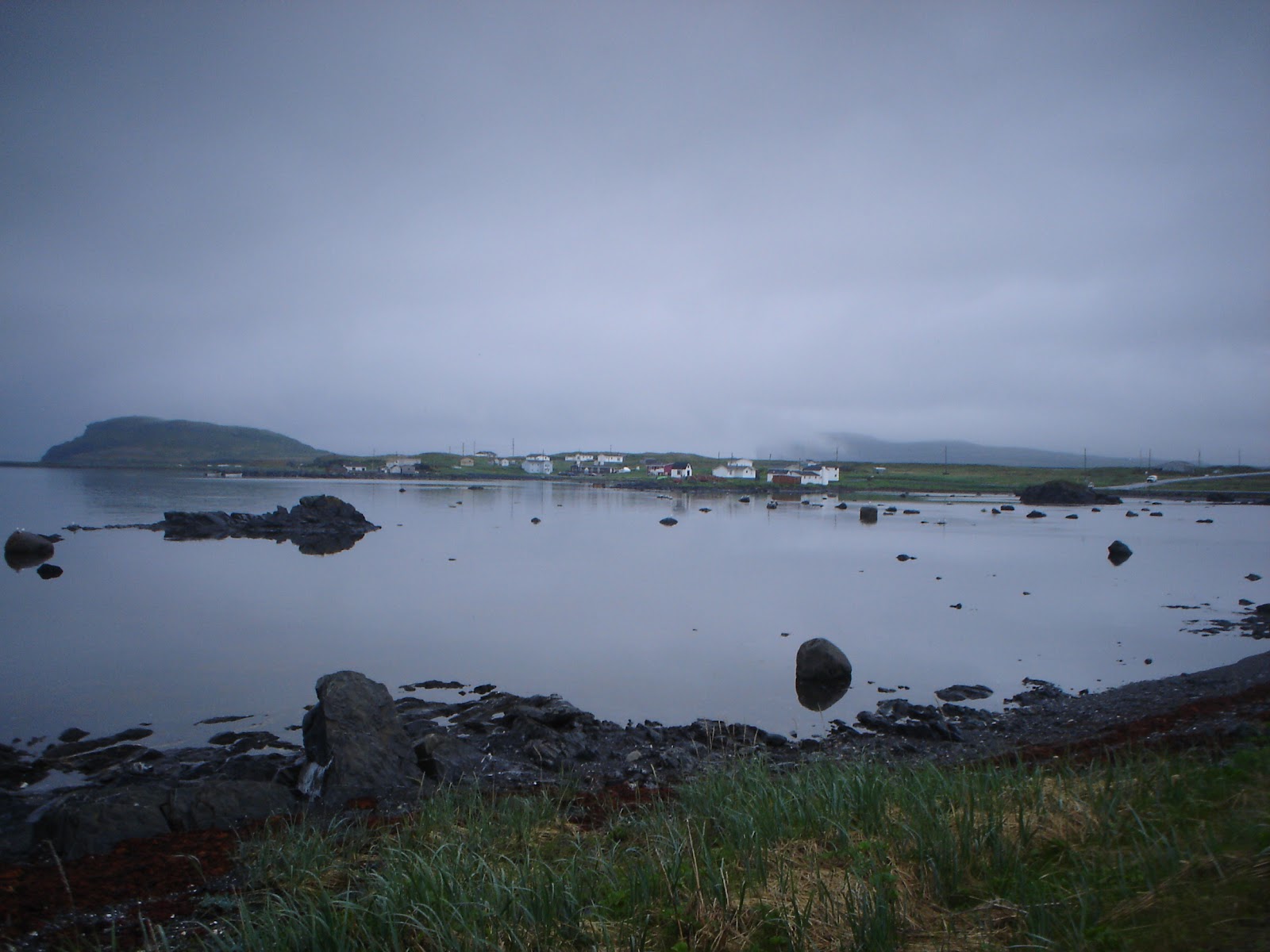
Another nice day on day #10. Today we will cross the Canso Causeway that separates Cape Breton from the mainland. Only 22km from where I start today. To my surprise I find that the causeway has a good paved shoulder. Only the bridge crossing the lock is a bit tricky. I have to swing into the traffic lanes but there is no traffic at that moment. Short stop in Port Hawksbury for a breakfast sandwich at Tims and from there we follow the old trunk road #4 to St. Peters. We find the Battery Provincial park at the channel that connects the Bras d'Or Lake with the Atlantic Ocean. We make camp at a great spot overlooking a big inlet.

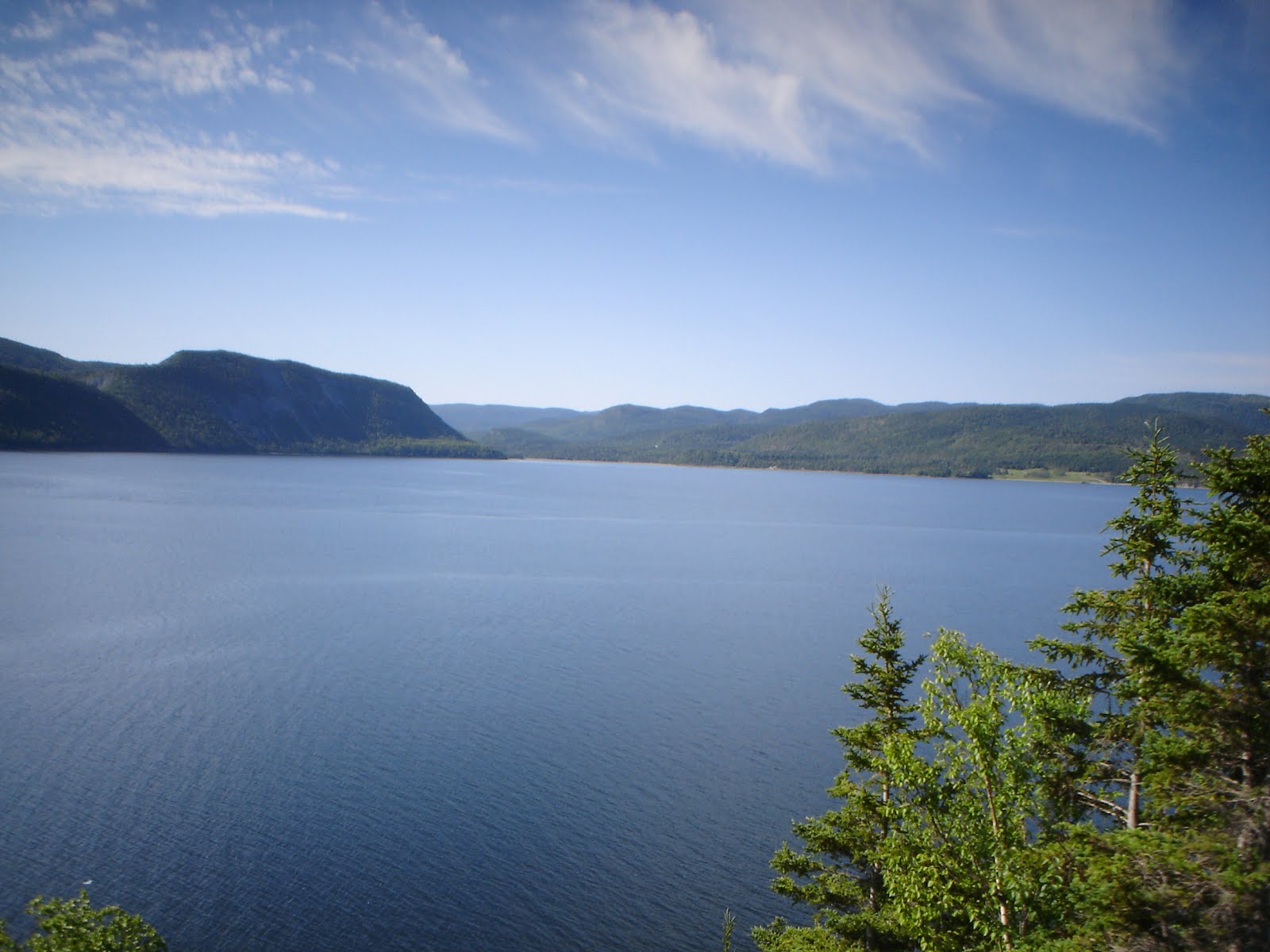
Mostly cloudy the next day #11. A fierce headwind develops shortly after we start and that combined with lots of steep inclines makes for the toughest day so far. The wind is no surprise, we are right at the shore of the Bras d'Or Lake. After 86KM of this we reach Sydney River where we pay a quick visit to the Superstore to bring up our supplies and have a quick bite to eat at McDonalds. Using their WiFi and internet I find a small motel just down the road but once we get there there is a small sign in the door "no vacancy". Find that hard to believe since there is not one car to be seen at the rooms. We are forced to go on for another 8KM to North Sydney where we get a room at the Highliner Motel. This made for a long day but we are less than 10KM from ferry terminal to NFLD.

We can take our time on day #12. The ferry departure time is 11:30am. When I reach the ticket booth I am asked if I have a reservation. No. Next I am told that the 11:30 is full and I can be booked on the next one leaving at 5:30pm. My insistence that there must be room for one person and a bicycle pays off. After a phone call I am OKed for the 11:30 sailing. Around 11:00 we board the MV Highlanders, a modern vessel that loads at 2 levels simultaniously. I make use of the time on board to work on my blog. The crossing takes about 6 hours and the Cabbot Straight is very calm. We reach Port aux Basques at 6:30pm (we are now on NFLD time, 30 minutes ahead of Atlantic time). By the time we are on the road again it is past 7:00pm and we check into the first hotel we see. Not surprisingly it is called Hotel Port aux Basques. To celebrate fathers day we have a beer and panfried cod at the restaurant. The cod was delicious. And now some more work to bring the blog up to date and that is it for today!