Sunday, August 14, 2011

Winnipeg & the trip home

Thursday July 28

“The Canadian" arrives in Winnipeg around 10:00pm,  2 hours behind schedule and  for the first time this trip we bike in the dark. It is 10:30pm by the time we arrive at the Sigurdsons house. Leanne, Jack and Lucy are waiting outside to greet me.


De rest of the family Leif, Eric and Kate are in Gimli and we will see them tomorrow.
Leanne has ordered a nice meal of sushi for a late evening meal.

Friday July 29

The Frost family arrives around 9:30am and all of us head for Gimli to the Sigurdsons cottage on the shore of Lake Winnipeg. It is there that we have the whole clan together for the first time.
The weather is great, the cousins play a lot on the beach and in the water and the adults have a lots of fun with Leif's newly acquired Sea-Do and with his Hoby craft (kayak with sail).


Saturday July 30

This weekend the Icelandic community in Gimli celebrates the Icelandic Independence from Denmark. There is a fair in town and a good display of fireworks in the evening that we watch from the beach at the cottage.


Sunday August 1

Before we know it it is Sunday afternoon and we drive to Winnipeg where we spend the last evening together at the Sigurdsons house.


Monday August 2

Suzanne, Matt and Julia leave early Monday morning for Toronto.
Lucy and I are staying for another week and we are fortunate to enjoy another weekend in Gimli with Leanne, Leif and the kids.


Tuesday August 9

In the evening  Bob and I leave for the train station, a 3.5km bike ride where we board “the Canadian" for Toronto departing Winnipeg at 11:30pm.


Lucy flies back to Halifax the next day.

Friday August 12

We arrive at the Halifax station at 6pm and bike the last 17km of this trip to our house on Greenmount Drive where we arrive at 8pm.


Wednesday, July 27, 2011

Hudson's Hope to Prince George

Day 41, Wednesday July 20,  73.1km

It is sunny starting off. For the last week we have had to deal with a head wind and again today. Initially we follow the Peace River Valley until we cross the river and then highway 29 heads for another pass of 930m to connect with Chetwynd and the Pine River Valley. 


Fewer trucks on this part of the highway and the ones we see carry long sections of pipe destined for a pipe line that is under construction. During one of my breaks a truck parks right next to us and we chat with the driver. Don't we look tiny compared to that truck!


We reach the summit at 12:40pm and expect to pick up speed descending towards Chetwynd but a fierce headwind is slowing us down. Reaching Chetwynd there is lots of dust and sand blown around and by the time we reach the tourist information center I am eating sand. 
There is a RV park 15km further down highway 97 or we can go 2km in the opposite direction to the Westwind RV park. Bob and myself don't feel like fighting this headwind for another 15km and choose  for the Westwind RV park. As to be expected, this RV park is like another work camp for migrant workers.
The main street of Chetwynd is lined with wood sculptures.


Day 42, Thursday July 21,  64.3km

A bit of rain overnight to make sure we will pack a wet tent. By the time we are leaving the sun is peeking over the mountains. We are heading for the part of highway 97 that was closed a few weeks ago due to washouts. What we are traveling now has parts of the shoulder washed out but I guess that is minor compared to what lies ahead. At 8:30am we reach the area where major reconstruction is ongoing and the highway is reduced to one lane for a stretch of 8km. I am told by the flag person that I am not allowed to ride my bicycle on this stretch and will have to hitch a ride in the pilot truck.


There is a wait of about 30 min before the traffic that is lining up now can go through and that gives me lots of time to take the paniers off the bike and to unhook Bob. There are actually 2 pilot trucks, one in the front and another one at the end of the queue. We will be riding in the one at the end. 


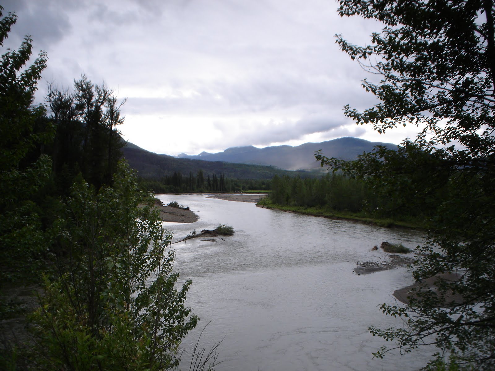
Here is a picture I took from the pilot truck. One lane of the highway was washed out and had to be reconstructed starting from the river's edge.


Once past the construction area biking is very pleasant. The traffic moves in blocks with a half hour lull in between when I have the highway to myself. We are still biking alongside the Pine River.


At 1:30 we reach the Silver Sands lodge/cafe and RV park where I am told that there is no room but after they realize that I am tenting I am allowed to camp near a creek on the property at no charge. Shortly after the tent is up it starts raining and I move inside and doze off.  When supper time rolls around it is still raining and I head to the cafe for a mushroom burger from the limited menue. Unfortunately the meat is way overcooked.

Day 43, Friday July 22,  89km

It rained most of the night. It has changed to drizzle by the time I emerge from the tent. Once again we fold up a wet tent and everything we touch feels damp. Are we having fun yet?
Right after leaving Silver Sands we run into another construction zone. This is not as a result of  washouts, it is a planned re-alignment and repaving of highway 97 but what a mess it creates. We have to work our way through 12km of soaking wet gravel road and at one point the gravel is so coarse and loose that we have to walk, not an easy task with all the weight on the bike. After 1.5 hours of bike time we averaged less than 10km/hr, this is going to be another long day!


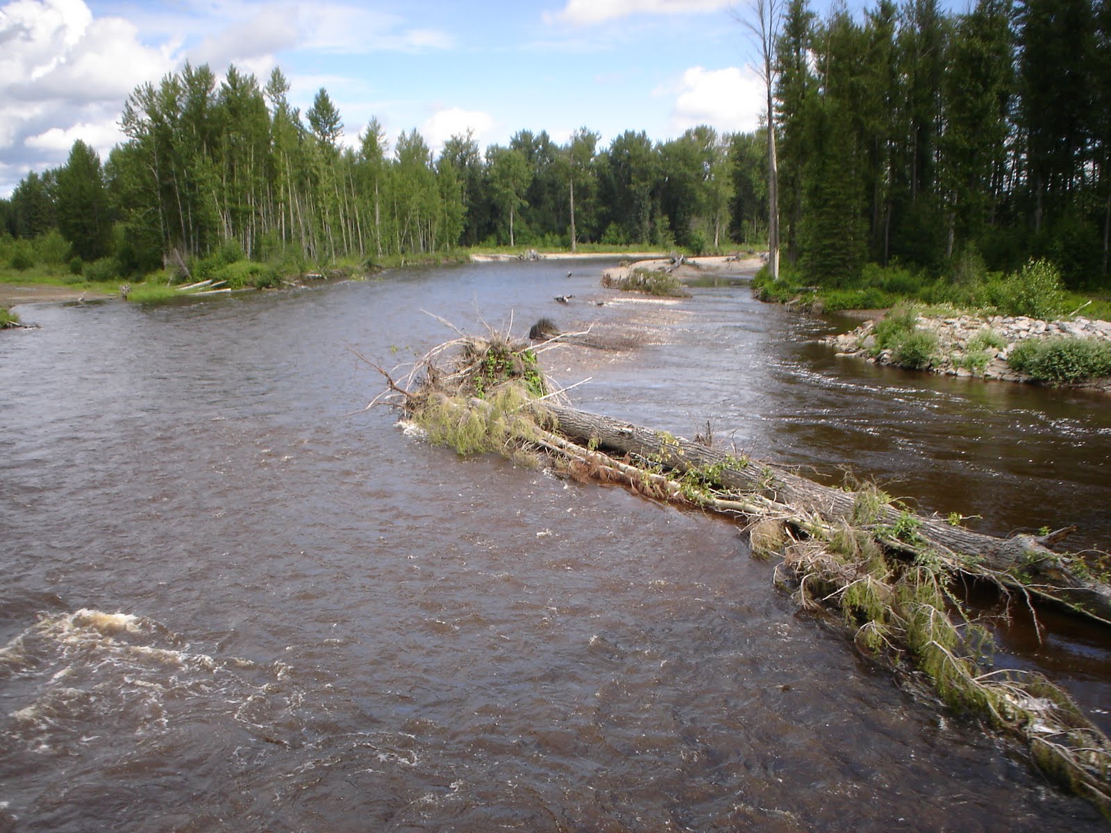
Past the construction zone we have time again to enjoy the scenery which is quite nice. High tree- covered mountains on both sides. We even see a few mountain streams with clear water and you don't see too many of those anymore with all the soil disturbing that is going on.


We are heading for our last mountain pass for this trip, the Pine Pass at 933m. We reach the summit at 9:30am and it is damp and cold. I have to dig up my gloves before we start the descent.


After the summit the skies are getting lighter and once we reach the Tudyah Lake provincial campground at 3:15pm the sun is  making an appearance once in a while. This is probably a nice park when the weather is good but everything is wet and puddles everywhere, cars have left big ruts in the grass and there are lots of mosquitoes.
First thing to do now is to hang our wet stuff out  to dry.

Day 44, Saturday July 23,  75.8km

Guess what! We folded a dry tent this morning. Cloudy skies this morning but it does not look like rain right away. Once again we have a headwind. I think that we have had a continuous headwind since we dropped down from Steamboat Mountain on July 10.
We are biking alongside McLeod Lake and it is long and narrow.


Just before we reach our destination we see some good examples of the pine beetle devastation.


We reach the Crooked River provincial campground at 2pm. This park must have better drainage, there are no puddles and for a change we are not bothered by mosquitoes. The sun makes an appearance in the afternoon. Most of the afternoon we relax in the hammock.

Day 45, Sunday July 24, 76km

The last day of our bike trip has arrived. This will be the last time getting up at 4am for a while. Every morning before getting out of the tent I flex the ankle joint on my right leg while massaging the area just above the right side of my knee. It is a bit painful but since I started doing this on July 12 my leg has been problem free.
Another cloudy morning and while making breakfast it starts raining. My plea must have been heard, it is only a few drops and no more.
Highway 97 is mostly at an elevation of around 700m and I expect it to drop down near Prince George. We do descend to an elevation of 600m in the Salmon river valley.


Once we pass the bridge across the Salmon River the highway keeps going up and once we reach the "Welcome to Prince George" sign we are up to 740m. It is another 12km to our destination from here. The highway now turns into a divided highway but they forgot to add a shoulder, traffic is passing us too close for comfort. It is not until we are close to the Nechako River bridge that the highway descends steeply and we get our free ride.


Shortly after the bridge we reach the last GPS waypoint of our trip and find our way to the Economy Inn where we stayed on June 1. We arrive there at 1pm. They have a room available with direct street access and I can store my bike inside.


It took 45 days and 2976km on the bike and 8km on the pilot truck to get from Valdez to Prince George.
Time to celebrate! Supper at Shooters and Sleemans Honeybrown is on tap. Life is good.

Monday, July 25, 2011

Arrived in Prince George

This is a short post to let you know that we arrived in good spirits at the Economy Inn in Prince George on Sunday July 24 at 1pm, one day behind schedule.
It took 45 days and 2976km to bike from Valdez to Prince George.
Details to follow in next few days.

Tuesday, July 19, 2011

Fort Nelson to Hudson's Hope

Day 34, Wednesday July 13, 101.4km

This is going to be a sunscreen day. Shortly after leaving Fort Nelson we reach the lowest point of the AH at the bridge of the Muskwa river at an elevation of 280m. The warm weather brings out the next pest to deal with:  there are a dozen horse flies around me and no matter how fast you bike, they do circles around you. Very few actually land on me.
Looks like we have started the least interesting part of our trip. The road is straight and a bit boring.


There are very few rest places and most times we have to take our breaks at the side of the road.
During one of those breaks I am laying down after a snack to rest my back. I hear a car horn beep and looking up I see a compact car parked at the other side of the road about 50m away. After a few minutes the car drives up and the driver informs me that there is a black bear on the other side of the road from where I am. I thank the driver and after he drives off I get up to investigate. Yes, there is a black bear minding his own business. I blow my whistle to let him know that I am near but he does not react and slowly moves on his way.
I go back in horizontal position and a pick-up truck passes and makes a u-turn. Two girls inside warn me about the bears present and I reply that I am aware and that the bear has been there for a while. They make another u-turn to continue their trip.
By the time I am ready to get back on the bike the bear is out of sight. Now a truck approaches from the direction I came from and I see something flying off that truck and bouncing a few times on the paved shoulder before it disappears in the green belt not to far from where I am standing. I find the piece that came off the truck and take a picture.


This is proof again that the real danger out here is not the bears.
The destination today is Prophet River but when we arrive there the campground is closed down and we have to continue on to find a good spot to camp in the wild. We find that spot at Bougie Creek. There is nobody around but me (and the bears?)


Day 35, Thursday July 14, 79.7km

Once out of the tent I find 3 other tents nearby. They must have arrived last night after I went to sleep.
It looks like another sunscreen day. It is tough going today. It is hot and progress is slow and I am wondering if we will make it to the Bucking Horse River.
Later in the day a thunderstorm develops and passes on our right.


That storm seems to organize itsself into a bigger storm right behind me.
Looking back the sky is ink black and it seems to follow me.


 It has cooled off considerably and we make it to the Bucking Horse River. It is clear that rain is on the way and we opt for a room in the Bucking Horse Lodge. Within 10 minutes after checking in it is pouring rain. My tent was packed wet this morning and I hang it out in my room to dry.


Day 36, Friday July 15, 53.4km

It is Kate's 5th birthday today. Happy birthday Kate!
It rained most of the night. Glad that we went for the lodge last night.
The oil and gas industry is quite prominent south of Fort Nelson, creating a lot of truck traffic on the AH. Many of those trucks move wide loads.
At around 10am we reach a point where the AH drops down steeply into the Sikini River Valley. There are all kinds of warning signs about a steep grade down and that trucks should check their brakes before proceeding. What goes down will have to get up again and after we cross the river we start the worst climb of this trip so far. Unfortunately my side of the road is gravel, making the climb even more of a challenge. Halfway up the climb a truck carrying a really heavy load is coming down. It is actually a 2-truck combination. The one on the back is for extra pushing or braking. Have to get a picture of this one!


Shortly after 3pm we reach the Pink Mountain campground. It is raining on and off and I cook supper under the shelter we created out of the hammock fly.


Day 37, Saturday July 16, 65.7km

It rained all night and somehow water got under my thermarest matrass. That gives another wet item to deal with. Once we hit the road it is dry but soon run into patches of drizzle and wherever the AH gets up a hill it disappears into the clouds.


By 3pm we are biking in the rain. There are a lot of gas fields in this area with a lot of muddy gravel service roads and a lot of trucks. Whenever the trucks come out of the service roads they drag a lot of mud and clay onto the AH and that combination creates a real mess once it starts raining.
By the time we reach Wonowon both Bob and myself are covered in mud.


According to the roadsigns there should be a motel here and there is indeed a big sign near a gas station/convenience store announcing the Wonowon motel but there is no motel to be found. The owner tells me that once there was a motel but it closed quite a while ago. I would have loved to ask why he does not remove the bloody sign but decide against it.
What to do now? Tent is wet, thermarest is wet and we are not very dry either. I hate the thought of having to tent in the wild again.
Across the road is a camp for oil and gas workers called the Wonowon Lodge and there is a big sign that room and board is available. I pay a visit to the office and I can get a room for $100 for the night. Request for a discount for a very wet senior citizen is turned down. At this point I gladly drop $100 to have a dry place for the night. It is cash only and I have enough on me to cover this. Later the girl I deal with has talked to the manager and they will include supper and breakfast. Now it starts to look like a good deal.
Later the rain stops and Bob and the bike dry up enough for me to wipe off all the mud. All the wet stuff is drying in my room. Another long busy day came to a good end.


Day 38, Sunday July 17, 77.2km
Breakfast is served starting 5am and before that time I have the bike ready for take off and it is dry!
But drizzle has started again by the time I finish breakfast and everything is soaking wet even before we hit the road.
At 11am we hit a big thunderstorm and we wait at the side of the road until the worst is over. No doubt we will get covered in mud once again.
Once the storm clears it looks like better weather is in view and by the end of the day we are in full sunshine.
At 2pm we reach the point where we get off the AH. The Charlie Lake provincial park is right here at the intersection.


We are early today and have time to get Bob and the bike back into reasonable shape. The chain is very dirty and I do the best job with the limited means available. I also install new pads on my Spongy Wonder seat. The old ones are showing signs of wear.


Day 39, Monday July 18, 79.6km

Today we start highway 29, the Don Phillips Way and count on having an easier time on this highway.

But we find out otherwise. We soon run into bulk carriers about every 5 minutes. There must be a mine nearby. Soon the highway 29 drops down into the Peace River Valley with a grade of 10%.
The campground attendant of the Charlie Lake campground told me that this valley is going to be flooded. BC hydro is planning to build a dam backing up de Peace River. Looking at the signs there is a lot of opposition to this project.
I was hoping that highway 29 would stay down in the Peace River Valley but wrong again. Twice it climbs back on the plateau with grades of 10%. Now I am really climbing the worst hills of this trip.


On top of that we have a fierce headwind and there are still lots of trucks. This is still an oil and gas area.
The valley is beautiful and we get some great views once on the plateau.


When sitting down for lunch I get another bear warning from a road crew nearby. They spotted a black bear earlier at the side of the river.
Nearly exhausted we reach Hudson's Hope at 4pm and get a warm reception at the visitors center.
All that I need is here. The campground is a few blocks down the road and the campground attendant suggests I pitch my tent under the shelter.
Hudson's Hope is a pleasant little town and people are very friendly.


Day 40, Tuesday July 19

Scheduled rest day today. Slept in till 7am and had breakfast at the campground. Laundry next and after that off to the tourist information centre to work on the blog. I have a good setup here and I get all the help I need.

Another good wind blowing again from the west. Glad we are not biking today.

Tomorrow the destination will be Chetwynd and according to the campground attendant I have some good climbs ahead of me. He also warned me of the Pine Pass on highway 97. That is the part of the highway that was closed earlier due to washouts. There are delays on the highway of up to 2 hours and traffic will be moving in blocks. Something to keep in mind.

Friday, July 8, 2011

Coal River to Fort Nelson and Fundraiser Update

Watson Lake to Coal River Lodge

Day 25, Monday July 4, 106.3km

On the bike by 5:30am and it is only 1degC, nothing like a good hill to warm you up. Shortly after leaving Watson Lake we enter British Columbia again. By the end of the day we will have crossed this border 6 times.
Now we see big turds at the side of the road. Who is leaving those behind?


A little down the AH we find out. These pictures are taken while biking. Just this moment that darn pedal starts squeaking again. Hope it does not annoy the big beast. No, he just looks me over and continues with what he is doing.


Just before 10am we see a black bear at the left of the road, digging for roots. He looks at me at keeps on digging. Did not stop for a picture.
Shortly after noon we reach Contact Creek Lodge. Not much there, not even a campground. I am glad we selected Watson Lake for our day off. Contact Creek Lodge is our target for today but we decide to keep on going and camp in the wild. It is still early and the going is good. There are good views of the Liard River.


I don't want to bore you any further with steep hills. They are a part of our day. At around 1pm we pass another buffalo. At around 2pm we pass the border for the last time and will be in BC for the rest of our trip.
At 3:15pm we spot another black bear at the left side of the road. This time I rung my bell and he disappeared in the woods before I could snap a picture.
At 3:30pm we have done 97km and it is time to look for a camping spot. For quite a while we have not seen any water. This could become a problem. We spot another black bear, this on right besides the road. We kind of surprise him and this time I manage to snap pictures while biking. He starts running, away from us!


At 5pm and 106km the AH finally crosses a deep gully with enough water flow. Not the best camping spot but it will have to do. The bike is close to the road and I pitch the tent in the woods, not visible from the road. I ring the bell and blow my whistle at regular intervals to warn bears of our presence. Prepare a quick meal, and then in the tent and soon I am asleep. At 10:30pm I am awakened by a car stopping and a car door being slammed shut. Somebody is calling if there is somebody back there. I reply and he wants to know if everything is OK. He spotted my bike on the side of the road. I assumed this to be the RCMP and gave him the green light.

Day 26, Tuesday July 5, 43km

That darn leg is acting up again. On the bike by 7am and my leg is not 100%, still feel discomfort in the upper part but we seem to be able to bike. I have not mentioned my back and shoulder for a while. They are OK again. But that darn leg worries me. If it gets really bad I will take all paniers of the bike, unhook the trailer, put everything on the side of the road and try to get a lift to Fort Nelson and continue from there by Grayhound bus. I sincerely hope that it won't come to that!
Shortly after leaving we spot a small herd of bison. I count 7 of them.


At 8:10 a tractor trailer stops on the uphill and the driver informs me that he spotted 3 grizzly bears at the side of the road, about 5 minutes down the road by bike. They must have been gone by the time I got there, I never saw them. The AH now drops down into the Liard River valley with some good views of the valley.


Shortly after 1pm we reach the Coal River lodge and they do have a campground and small restaurant and internet. I am presently sitting in the restaurant working on this blog update.

Saturday, July 2, 2011

Whitehorse to Watson Lake

Day 18, Monday June 27, 80.7km

Up early as usual. While making my breakfast mother nature is calling and I make one step in the direction of the restrooms and out of nowhere comes a shooting pain in my right lower leg. Must be a cramp and will be gone in a minute. It is not. What the heck is wrong now, I just had 2 days rest! Can't even determine where exactly it originates. I cannot stretch the leg. Mother nature is not going away, no choice but to limp to the restroom. Back on my site I sit down at the picnic table, massage the lower leg, flex it and finally manage to stretch it all the way. The pain slowly disappears and we finish breakfast and packing. Can't be a muscle, must be a nerve or tendon issue. Whatever it is, let's hope it is gone.
There is a steep long hill to get back on the Alaska highway (abbreviated to AH from here on) from Whitehorse and I wonder how my leg will be holding out. The leg feels normal, figure that one!
The weather is great again, sunny and blue skies. Leaving Whitehorse the AH follows the Yukon river for a while with some nice views of the river.


Once we leave the river we clearly enter a semi desert again, not much water around. The forest is no longer black spruce, what we see now looks like pine. Today we have a slight headwind to deal with but it is not unpleasant with these warm temperatures.


We reach Jakes Corner around 4pm. It is a collection of run down buildings and a few gas pumps at the junction of the AH and highway # 8. There is a restaurant where the tired traveller can take a shower for a price. I ask the girl behind the desk if there is a place to pitch my tent and she replies that this is the Yukon and I can pitch my tent wherever I want as long as it is not in the way. I have a meal of chicken enchilladas with mexican beans and make use of their shower facilities. I pitch my tent at the other side of the AH where there is a level spot in the shade. I fill my foldable bucket with water at the restaurant. Now I am all set.

Day 19, Tuesday June 28, 84.4km

This camping spot at Jakes Corner is buggy, lots of musquitos and some blackflies as well. I have to dress accordingly, wearing my jacket with hood and my long biking pants. They are too thick for the musquitos to penetrate with their stingers. My right leg is acting up again. Same thing as yesterday and I give it the same treatment. It comes from within my lower calf on the right side of the leg and it is most painful when I come up from a kneeling position. Can't explain this. I had a really good rest, went in the tent at 8pm and almost directly fell asleep.
It is mostly cloudy today but a pleasant temperature for biking with a wind of about 20km behind us. However, we are biking direction northeast and in a while we will make a sharp turn to the south following the shores of Teslin Lake and then we will have the wind against us. We have done 36km so far and my leg is fine. There is a lot more traffic on this stretch of the AH and a good number of tractor trailers. A lot of those are tanker trucks and I wonder if there are oil wells around here.
Shortly after we cross the Teslin river there is a sideroad to the left. There is a sign indicating a display of historic significance and we go in to investigate. It is the Canol road and the picture speaks for itself. Those wrecks are relics from the second world war.


We are now following the east shore of Teslin lake and we now have a headwind to deal with . A few rain drops are falling down and I change to raingear. A girl on a bike with a Bob coming from the opposite direction swings to my side of the road and asks if I have any trouble. She is from Italy and speaks a little bit of English and is biking from Patagonia to Alaska. Now there is an adventure for you!


At 2:45 we reach the Teslin Lake campground and self register for site number 20, the closest to the shelter. It is raining softly now.

Day 20, Wednesday June 29, 80.4km

That rain did not last very long, later the sun came out again. No rain overnight. Leg not acting up. Just past the town of Teslin is a long bridge across the Nisutlin bay. The bridge surface is metal grates and it is a bit scary to cross it on narrow bike tires.


Shortly after the bridge is a very steep hill up. In my grading system this is partly a 11standing (first 1 is for smallest chain ring front, second 1 is for largest chainring rear, standing is for standing up on the pedals). On hills like this I make regular stops to let the heart rate come down. Don't forget, I am pushing a heavy load! On the hill we have a great view of the town and bay.
We are battling a headwind today. After 2.5 hours on the bike we only have 35km to show for. We are struggling today. During lunch a few raindrops start falling. The skies do not look very promising and I put on my raingear. The AH straddles the border between the Yukon and British Columbia and crosses it several times. At 1:15pm we cross into BC for the first time and we will be in BC the rest of today.

We arrive at our destination for today around 4pm. We are wild camping at the Smart river. I did a good job researching this spot using Google streetview. Lots of room to pitch my tent and a river with cool clear water.
When we arrive Stephen is there taking a brake. I first met Stephen at Starbucks in Whitehorse, next we met again at Jakes Corner and earlier today he caught up with me and we biked together for a while. We are too slow for Stephen and he pulled away after a while. He ran into some folks picking mushrooms and they gave him a bag full of morels. He gave me half and I fried them up and put them in my chili. That is probably not the best way to taste morel mushrooms but they were a pleasant chewy addition to the chili. Stephen started in Vancouver and his goal is to cycle 25000km throughout Canada to raise $1million for the Canadian Cancer Society. May the wind be in you back Stephen!


We had one brief shower today, I could have done without my raingear.

Day 21, Thursday June 30, 78.2km

Up at 4am and notice frost on the paniers. The temperature is 0 degC.


While making breakfast the dew on the tent fly freezes, I can't take it down until it is defrosted. Best thing to do now is to crawl back into the sleeping bag to get warm again. I doze off and when coming to again notice waterdrops rolling down the fly. Time for action. Due to this frost delay it is already 7:30am by the time we hit the road. The sun is out but it is very hazy. We may be running into rain later today. There is a little bit of wind and it is behind us. At 11:15 we are back in the Yukon and at 11:45 we are partly up a very long steep hill , no wonder, we are heading for a summit of 1020m in elevation.


At 14:10 we reach a sign announcing the Continental Divide.


Shortly after we reach the summit of 1020m and enter the narrow valley of the Rancheria river.


It is all downhill from here to reach our destination: the Rancheria Lodge and campground. The lodge is pretty run-down but there is a restaurant and the folks are friendly. I really like my camping spot under the pine trees.


While working on my notebook in the restaurant I am approached by Juan. He is from Spain and is also biking from Patagonia to Alaska. He already had seen my bike and the strap system I use to lock the handlebars in place to prevent Bob from jack-knifing and he is quite impressed by that. Juan started out with a Bob trailer but gave it up in SanFransisco after he damaged his derailleur arm 6 times.

Day 22, Friday July 1, 101.1km

Happy Canada Day! We will have a late start this morning. I have to make a phone call to Bell Mobility for Lucy so she can change her cell phone plan and the restaurant does not open until 7am and that is the only place where there is a phone. Bad timing! Bell Mobilty is closed due to the statutory holiday. We are on the road at 7:45am. The sun is shining and blue skies once again. We continue going downhill following the narrow valley of the Rancheria river.


At 11:40 we reach the calculated halfway point of our trip at 1394km.


We reach the end of the valley and move away from the river. The landscape has now changed to long rolling hills covered by pine forest and the road follows these long rolling hills with long downslopes and what  seems to be longer and steeper uphills. We are working our butts off. The schedule calls for 97km and with this wind behind us we may make that distance today.


At 5:40 we reach Junction 37 Services, our target for today and have a great stir-fry followed by a slice of apple pie at the restaurant  By the time we get to our camping spot we have done 101.1km.


Day 23 Saturday July 2, 30.7km

The schedule is just a little bit too aggressive and I am going to deviate from it a bit. After yesterday's 100km day we are going to slow down a bit. Today we will bike to Watson Lake, stock up on food, do laundry and blog update and rest tomorrow as well.
Up at 6am this morning. Earlier I had to go to the washroom and that darn leg was acting up again but now all is back to normal. The sun is shining once again. We only have to bike about 22km today. What a luxury! Soon after leaving we coast down a steep hill and cross the Liard river. We will see more of this river in the coming days.


What goes down has to go back up and soon we are climbing a long steep hill to get out of the river valley.
We reach Watson Lake at 10am and  pay a visit to the forest of signs and the Tourist Info center.


There we learn that highway 97 between Chetwynd and Prince George is closed due to several washouts and will remain closed for the next 2 weeks. Our schedule puts us in Chetwynd on July 19, hopefully they will have repaired the road by then. We certainly will have to keep checking this. Also got useful information on the route from Watson Lake to Fort Nelson. I have calculated that we have to carry food for 7 days. We will be heavy when we leave Watson Lake.
I am presently at the public library to work on the blog and Bob is patiently waiting outside. No Wifi here, I have to use one of the library terminals.

Day 24, Sunday July 3.
A very relaxing day. Slept in until 8:45 and went for breakfast. Now trying to find a place with decent wifi to connect with my blog and do some cutting and pasting from my notebook.
This would have been a good day for traveling, there is a good wind blowing from the west and it is sunny again. I can't believe my luck with all this great weather. I do not regret taking an easy day yesterday. I am now one day behind schedule and there is not much slack left to make up for it. I made the schedule a little bit too aggressive.
I have to mention Wim. I met him for the first time at Buckshot Betty in Beaver Creek. He was sitting at the table with 2 other guys and they asked me to join them. Wim had just met the 2 other guys at the campground. Wim is from the Netherlands and is biking from Alaska to Patagonia. He quit his job and follows his dream for the next 18 months. I met Wim again at the public library in Whitehorse and we had a pleasant conversation. Wim has a web site and the link is
www.heebels.nl