Saturday, June 25, 2011

Beaver Creek to Whitehorse

Day 10, Sunday June 19, 81.3km

With 24 hour daylight why not have a little experiment and start really early. We are up at 2:35am and on the road by 4:00am. It is mostly cloudy but the sun is poking through a little hole in the sky causing a red glow to appear over the mountains.


It is very quiet and no traffic. Rain starts around 8am just when it is lunch time. I make a shelter with my hammock fly to keep the rain out of my lunch box.


The rain lasts until we reach the Lake Creek campground. It is a soft steady rain and my rain gear is keeping me dry. This part of the Alaska highway is under construction and in many places the asphalt is gone and we are biking on gravel.


The campground has no water. No problem, we use the river and our filter. There is a shelter and that one comes in handy now that it is raining. A friendly German couple that is just leaving the campground offer me hot coffee with a little bit of milk from their thermos. They are very interested in my bike and trailer and want to know all about my trip. That coffee certainly hit the spot. After a while the rain stops and the sun makes an appearance.

Day 11, Monday June 20, 68.1km

It started raining again during the night and we have to delay our departure. It is still raining at 5:30am but I have had enough. Awake for quite a while I now want to move on. I have worked out a plan to move everything under the shelter to make breakfast and to pack there. During packing the rain stops. We are late this morning, it is already 8:30 by the time we hit the road. This is the first day that the wind is against us.


One cannot quite trust the signs along the highway. You may find an official sign announcing tourist services upcoming 2km down the road but once you get there it is obvious that the business closed down a long time ago. But this time there is a business that is open. It is a French (not from Quebec) couple that started this bakery in the middle of nowhere. I have a coffee and a raisin cookie.


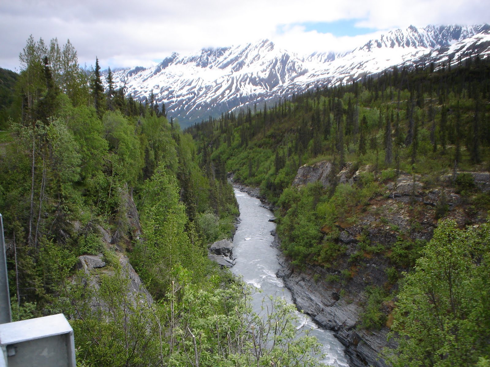
The scenery remains very enjoyable in every direction.


The wind makes it so much harder to make headway and after 68km I call it quits. We are 22km short of the target for today. We find a level spot near a stream and that is all we need. I ring my bell and blow my whistle frequently.


If we make an early start tomorrow we may be able to make up the 22km while the winds are light.

Day 12, Tuesday June 21, 67.5km

Rain again overnight but by 4am it is dry and we pack a wet tent. It does not take long to make up for the 22km now that there is hardly any wind. Kluane lake starts at Burwash Landing.


From one of the road signs we learned that the nearby Kaskawuish glacier drops cold air in the valley causing winds to blow in the Slims River valley and along Kluane lake. That must explain yesterday's headwind. Showers start again around 10am but they have ended by the time we reach Cottonwood campground.


This area of the Yukon has the highest concentration of grizzly bears in north America. For this reason the campground has no garbage cans. I did not see any grizzlies but ...... maybe I should not complain about that! This turned out to be a really nice day. The sun came out in the afternoon. The girl at the office told me that the forecast is good for the next days and it will be warming up.

Day 13, Wednesday June 22, 86km

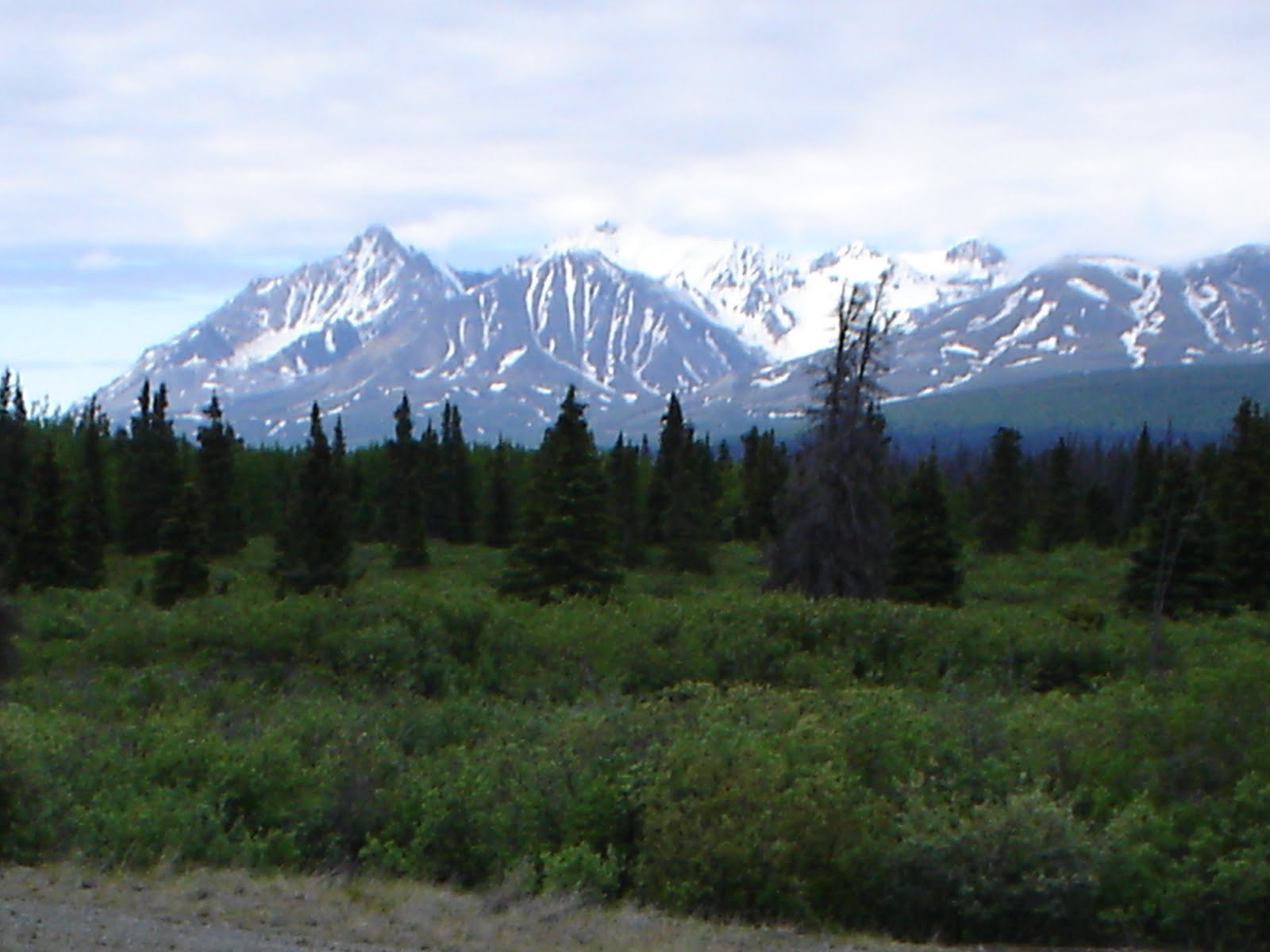
I really like the Yukon. The scenery is really up there. Since Beaver Creek we have been surrounded by mountains at both sides. The ones on the right are higher and still have snow on top. We got up at 3:30am this morning. It is mostly cloudy and there is hardly any wind. We are now biking towards the end of Kluane lake.


At the end of the lake 3 valleys merge, one of those is the Slims river valley. The road hugs the lake and once we corner a cliff and can see the Slims river valley, we all of a sudden are battling a strong head wind. This is the wind that is caused by the Kaskawuish glacier.


The Alaska highway does not follow this valley, but rounds the end of the lake and follows the valley that continues south. This is great scenery and a big part of the area is the Kluane national park.


We are now leaving the lake behind us at an elevation of 850m and start climbing to 1020m with many ups and downs but more ups and with a headwind estimated at 20km/hr.


The lake is still under heavy clouds but towards the south we can see blue skies and that is where we are heading. The summit of 1020m is the highest point of the Alaska highway and we get there by 9:45am.


By 12 am we are in full sunshine and my jacket is too warm. We replace it by the bug jacket as protection against mosquitoes. They are on you as soon as you stop or when you are going slowly uphill. We dropped down to about 900m but another summit of 1010m is down the road. I am getting tired.


But then we go downhill nonstop for 10km and we enter the community of Haines Junction before we know it.


We check in at the Kluane campground and after making camp visit the tourist information centre to get information on facilities between Haines Junction and Whitehorse. When planning this trip I could not find any facilities and the only camping spot I could find through Google streetview was the muddy Mendenhall river 75km past Haines Junction. The 'no facilities' is confirmed by the girl at the information desk, however she suggests to wild camp at Stoney Creek, 94km past Haines Junction. There is good water there. We will plan accordingly for tomorrow.

Day 14, Thursday June 23, 95km

Out of bed at 4:35am, it is only 4degC and clear blue sky. The wind is light and in our back. Traffic on the Alaska highway is light and I estimate that 60% of that are RV's. Lots of rentals but also lots of tourbus-size RV's pulling another vehicle behind it. There are lots of motorcycles, few tractor trailers. We stop to admire a historic bridge and meet a fellow biker travelling north.


He started on April 26 in Texas and is on his way to the Arctic Circle. I have a very dry section ahead of me and he advises to take lots of water. I do have the luxury of 3 bottles of water, one on the bike and Bob is carrying 2 bottles as well. I do stop at a campground a bit further down to fill up my half empty bottle. A fellow sitting outside the little store smoking a cigaret warns me about a grizzly with 2 cubs just down the road. She hangs around there a lot and has been acting aggressively towards motorcycles yesterday. From there on I ring my bell at regular intervals to let her know that I am on my way. That must have done the trick, I never saw the bear and...... maybe I should not complain about that!
This part of the Alaska highway is indeed very dry. I read somewhere that this is a semi desert. No rivers or streams crossing the road for many miles. It has warmed up quickly. I have lunch at 11:15am and change into shorts and running shoes for the first time this trip.


This is a great day, blue skies and it is 20degC. We reach Stoney Creek at 3:10pm and it is perfect.
The water in the creek is cold and clear and there is a level spot. That is all I need. We now biked 1000km since leaving Valdez.


Day 15, Friday June 24, 66.5km

Now it is only 3 degC in the early morning but warming up rapidly. By 7:30am I have to stop to take off my jacket. A motorcyclist on a Harley stops to ask if everything is OK. We have a little chat. At 7:45am I spot an elk on the road. It is acting nervous, it is not the cars it is worried about, it is me. It turns back and tries again to cross the road, all that time looking in my direction. I manage to snap a picture and shortly after that it disappears into the woods.


 While recording this incident on my MP3 player a First Nations fellow stops his van and gestures me to the driver's window. He warns me about another grizzly with cubs just down the road that seems to hang around there a lot. He shows me pictures that he took of the bear yesterday. Yes, that looks like a good size grizzly. Again I ring my bell at regular intervals and again it must have done the trick. No bear showed up but ....... maybe I should not complain about that!
I count on arriving in Whitehorse early, however, at 8:30am we run into another 16 km of road construction. A few stretches of several kilometers where the road is nothing but coarse gravel. Difficult to keep going straight and I have to be very careful not to fall. If the oncoming traffic only would slow down, but many don't and spray us with gravel and dust. By 10am we finally reach the end of the construction zone.
Parts of the highway is built up to avoid having to go down in gullies and it totally amazes me that there are no guard rails. If any car would go over it would not be found for days. It is a bit scary to drive my bike on the shoulder right next to one of those drop-offs. Don't know if it shows up on the picture but here is an example.


Finally Whitehorse comes into view and by 1:40pm we are downtown at the tourist information centre.


At 3:15 we reach the Robert Services Campground and make camp.

Day 16 & 17, June 25 & 26
 
Today is Saturday June 25. The campground is in a wooded area on the Yukon River about 1.5km outside of Whitehorse. It is for tenting only and cars are not allowed on the campground, they have to be parked at the entrance of the park.
This morning we first are going to have a Tim stop, the first one since Prince Rupert. Next is the laundry and at 10am we have to be at the library where we can get internet access for a blog update. We are allowed one hour per day, not nearly enough to get everything done. How are we going to manage? Maybe I should look into getting a little notebook with wireless access, that would make blog life so much easier.
Off to Walmart we go and 2 hours later the notebook is up and running and wireless connected to the internet at the library. From here on the blog updates will be created on this little notebook. I probably saved some dollars by buying it in the Yukon versus Nova Scotia, sales tax is only 5% here. By the end of this trip it will have partly paid for itself by savings on internet charges. Hope this is not the straw that breaks the camel's back as far as weight is concerned.

Next we have to buy supplies for the upcoming days and I have a lead on a good place to eat a nice rack of ribs. Unfortunately there is a waiting time of 30 min to get in. I am not willing to wait that long, maybe try again tomorrow. Still have to boil a dozen eggs and off to bed.

By now it is Sunday and I am at Starbucks writing this part of the blog and hoping to connect to the internet but so far no luck. May have to try somewhere else. Weather has been great for the last couple of days, sunny and in the high twenties. Whitehorse emits a pleasant atmosphere but don't look for beautiful architecture. It looks like a typical northern town. It takes about 10 min to bike through Whitehorse. This town is on the Yukon river that flows for 3000km through the Yukon and Alaska before emptying into the Bering Sea. It has a drainage area of 847000 square kilometers and is the second largest river in North America. Learned this from the signs along the river.

This bike trip is a fantastic adventure. I cannot recall a trip where for 1000km one is non-stop exposed to so much nature and beauty and there is lots more to come. I can recommend this to anybody and this is a very good time of the year to do it. One word of caution, road condition between the Canada/US border and Burwash Landing (about 300km) is horrendous. There are ruts and potholes and bumps all over the place. I have seen several apple size holes in the asphalt and underneath it is hollow, ready to cave in on some poor unsuspected driver. I have seen numerous car tires at the side of the road, shredded to pieces.
I am pleased with the performance of my bike and Bob. No breakdowns so far and I am knocking on wood while writing this. The front paniers are great, they allow for a much better distribution of the weight and make reaching things easier. My only complaint is that the new paniers are not watertight. That is ridiculous for a product like this and I am planning to return them to MEC.
I am happy to report that for the last 2 mornings I have been able to get up from a laying down position on my back to sitting upright without discomfort near my right shoulderblade and back. Things are improving.
There is a second Starbucks in Whitehorse and that's where I am now wireless connected to the internet. Now I am full of coffee and the blog is up to date.


Friday, June 17, 2011

Valdez to Beaver Creek

Day 1, Friday June 10, 84.9km

Up at 4:30am and during packing I put 2 boiled eggs on the picnic table. When returning from the washroom I see a crow flying off with something white in its beak. Back at the table I notice that both eggs are gone! Oh well, I still have 10 left.
This is the first time we will be riding a fully loaded bike. We are taking off by 6:30, the temperature is 10degC.
I am pleasantly surprised to find a paved multi purpose trail parallel to the Richardson highway for the first 10km. After that we are on the road but traffic is light and there is a wide paved shoulder. The road is flat but that is not going to last. We have to get over those mountains to get to the interior of Alaska.


After a few hours we enter the Keystone Canyon with steep cliffs on both sides and many waterfalls rushing down.


Once through the canyon the view widens and the real work begins: the Thompson pass.


We start the climb at 10:00am and reach the summit at 2:10pm at an elevation of  824M. Had to stop many times to let the heart rate come down but we made it. The posts on the next picture are not lamp posts, they are markers for the snowplow. This pass is getting the highest snowfall anually in Alaska.


After the pass this great landscape just continues.


At 4:20 we reach our target for today, the rest area at the Tiekel river. To my surprise I find shelters with picnic tables and the river is close by as a water source. I pitch the tent underneath one of the shelters. This is a remote location and I use my whistle frequently to alert local bears. After preparing and eating a simple meal I am off to bed. My upper back and shoulder are hurting!


Day 2, Saturday June 11, 51.6km.

Up at 5:10am, I am late this morning. Bit of a chilly night, the temperature this morning is 5 degC. We only have to do 50km today, a breeze compared to yesterday. There is a cold wind blowing but is behind us. Mostly sunny with some scattered clouds.


We reach the Squirrel Creek State park by 11:10 and self register for site 7. The fee per night is $15, pretty steep considering the only facilities are pit toilets.
My site has lots of trees to hang my hammock and that is how I get through the rest of the day.


Day 3, Sunday June 12, 83km.

A bit more challenging to get everything done this morning. It is only 2 degC when getting up at 4:30am but the sun is already up and things will warm up soon. All dressed up and gloved I am going to work.
We start off with a long slope up, nothing better to warm you up. All of a sudden an annoying high pitch squeak is coming from somewhere on my bike when I pedal. What can it be? Better not be my headset or bottom bracket. I decide that it is the right pedal and put some oil between  the pedal and the crank arm.
We have now biked out of the coastal mountain range and the landscape is a bit flat but it does not take long for a good size mountain to appear on our right in the distance. It is Mount Drum, an old volcano and it is a part of the Wrangell mountains. We have to go all around those mountains and will be biking on the other side on the Alaska highway in a few days.


At 1:00pm we have reached the junction of the Richardson and Glennen highways and there is a tourist information centre where we get information on a possible place to stay for tonight. The Gakona lodge is about 3km on the Tok Cutoff highway, just a bit further than we have planned.
At 2:35pm we reach the junction of the Richardson and Tok Cutoff highways. There is an sign announcing 24 miles of road construction on the Tok Cutoff highway. Traffic is stopped by a flag woman. There is active construction on the next 3.2km and we have to wait for the pilot car. She suggests I take a lift with the pilot car but this is too involved with the bike and trailer. She agrees and suggest I go last, once traffic is moving again. She wants to know if I will be able to keep up with the traffic. Certainly not! When the pilot car comes back I will have to go to the side until the traffic from the opposite direction has passed.


I find the lodge just past the construction area.


People in Alaska are mostly friendly. The owner of the lodge tells me that there is no official campground but I can pitch my tent for free on the lodge property. I find a good spot behind the lodge to pitch the tent.
I really like their business hours sign.


I have a meal of meatloaf and baked potato and a salad at the restaurant. I really like Alaska. Life is perfect were it not for my upper back and shoulder blade. They are aching again after this long day.

Day 4, Monday June 13, 100km.

Just as I remember from Labrador, there is no dew. The tent is bone dry in the morning and that makes packing it up very easy. And there is 24 hours daylight.
We continue the Tok Cutoff highway today. Soon I run into more construction. It is all gravel on a 2.5 km steep slope up and if I put too much torque on the crank arms my rear wheel starts slipping.


A good thing they wet the road all the time otherwise it this would be a very dusty ride. The gravel lasts for 12 km and I am so glad to see pavement again. The annoying squeak is back again. I now am certain it is the left pedal. Try some oil on this one.
Great views on this highway, those Wrangell mountains are always in view on the right and in between tundra with lots of black spruce.


After about 60 km we are in the mountains again. There is a mountain range on our left now. These must be old mountains, the tops are very rounded. And those Wrangell mountains always remain in sight.


At 5:15pm we arrive at the Porcupine Creek state park. Again the facilities are minimal and even the hand pump does not work. No problem, Porcupine creek is nearby and I have my filter. Another hard working day is behind us.


Day 5, Tuesday June 14, 96.3km.

On the bike by 6:40am and we continue the Tok Cutoff highway. Those early mornings on the road are the best part of the day. Also the best time to see wildlife. At 6:50am there is a moose on the road and I take a picture while biking. Before I get close he is off over a steep slope. That squeak is back again. I do a close inspection of the left pedal.There is too much play in the bearing closest to the crankshaft. This is not a good development. These are new MEC pedals and they were not cheap!
The weather is starting to change. Thick cloud cover ahead and it feels damp. Feels like rain on the way.


The mountains are closing in on both sides. We go through a narrow valley and it starts raining. By the time we put our rain gear on it is raining hard. The valley opens up again and the sky lightens. Done with the rain for now. That squeak is driving me nuts. During a break I take the pedal off the crankarm (don't forget, this is left threat!). I don't have to take the tools to take it apart. I work some of my wonder oil into the area of the bearing and put it back on. Have not heard the squeak since. About 10km before Tok a paved multi purpose trail starts. We now have a road and trail all to ourselves. We reach Tok in light rain at 3:35pm and check into the Golden Bear Motel. There is a good grocery store here and we stock up. We will be heavy tomorrow. Have to lay down now, my upper back and that shoulder blade are killing me.


Day 6, Wednesday June 15, 81.2km.

Feeling much better after a good night rest. Ready for another day. Shortly after leaving the motel we reach the junction of the Alaska and Tok Cutoff highways and we are at the most northerly point of our trip. We are at 63deg 20.146' North. When we got up it was sunny but now a thick fog has settled over Tok. There is a paved multi purpose trail for the first 2km. The Alaska highway is straight as an arrow and flat here. Over the next few km's I see 3 moose. Soon we bike out of the fog. Looking back the fog bank is still there, there must be a big body of water near Tok.


We are back in the mountains again. The road is partly up the side of the mountains with a great view of the valley below. The road is never flat now, I am either working hard to get up long hills or coasting down at the other side. This is the way it is going to be until we reach Beaver Creek.


We reach Northway Junction at 3:00am and there is a gas station / general store / campground run by the natives where we will camp for the night. Fee is $10 and $2 for a shower. The showers are at the store, only facilities at the campground are 2 outhouses and everything looks run down. The tap water at the campground has all kinds of particles floating in it. Making good use of my filter this trip. I have my $2 shower at the store. The shower stall is clean but I don't want to touch the shower curtain, it is black with mildew.
According to my GPS sunrise is at 3:21am and sunset at11:32pm at this location. No wonder it does not get dark.


Day 7, Thursday June 16, 99.2km.

We depart Northway Junction at 6:30am. Although this is my scheduled day off, I will delay by one day. There are no facilities here and I may have better luck in Beaver Creek. There is thick cloud cover in the south, the direction we are heading. At 11:00 it starts raining and we change into rain configuration. The rain does not last long but there is more on the way.
I see an interesting sign on the side of the road, let's have some fun with this.


We reach the Canada - USA border at 2:20pm and take some time to look around. Canada customs is 27km further down the road near the community of Beaver Creek. Sorry to say goodbye to Alaska. That was a tremendous bike ride,  Bob and myself really have enjoyed ourselves. We are now entering the Yukon, yet another province we can add to our list. We move the clock ahead by one hour, we are now on Pacific time. The road surface changes from smooth asphalt to coarse chip sealed stuff. A sign announces road construction ongoing for the next 185km. We are already running into to sections of gravel and it is very dusty.


Just before we reach Canada customs it starts raining again. There is a bit of a lineup. Can I jump the Q? Better not take any chances and I wait in line in the rain.  Besides the usual questions the officer also wants to know if I carry bear spray or other irritants. Yes, I do. As long as it is clearly labeled that it is intended for bears it is OK. Glad that they did not take it from me!
It is raining hard now and I check into Ida's motel.


Day 8 & 9, June 17 & 18

Today it is Friday June 17 and it is my day off. We are in the community of Beaver Creek, the most westerly community in Canada. The visitors center gave me a lead to a RV park where there is free Internet access and that is where we are now working on updates to the blog. There is also free coffee and a laundromat so I can do my washing at the same time. We checked out of the motel and will be camping in this park tonight.

Time goes fast, ......by now it is Saturday June 18 and it is 7:20 in the morning and I am still blogging. Did not get it all done yesterday and since facilities are great here, I decided to take another day off. This will give me a good rest and it will be a good feeling to get this blog up to date. We will still be on schedule.
It is satisfying to know that some child may benefit in the future by me doing this.
We now have 20 followers and already lots of comments. Thank you.

Juneau to Valdez

Tuesday June 7

The ferry leaves on schedule at 1:00pm. This time we are on the M/V Kennicott, a much nicer boat than the previous one. On the top deck I find a solarium with recliners and in no time my bed has been made up. We will be on this boat for 2 nights. The first part after leaving Juneau we continue the inside passage and after a few hours we head for the open Pacific with its groundswells and the boat starts to roll slightly but it does not bother me now.


The ship has a cafeteria and even a lounge. They even serve beer on tap, can it get any better?  After ordering one of those I leave a tip but it is refused. State employees are not allowed to accept tips in the state of Alaska. After I sit down I find this sign on the table.


Several times I wake up during the night. At 11:30pm it is still light, at 1:00am it is still light. We are so far north now that it does not get dark at all.This trip is going to be cheap on flashlight batteries! The ship is rolling pretty good but I am still OK.

Wednesday June 8

The M/V Kennicott makes one stop in Yakutat from 6:00am till 9:00am. We are allowed off the boat and I find a general store with a surprisingly good produce selection and I buy a few apples. Back on the Pacific the groundswells are getting bigger and the ship starts to roll and pitch a bit more. Unfortunately it is a bit more than I can handle and at one time I am pretty close to puking. Earlier I had discovered that when I am horizontal it does not seem to bother me so most of the of the day I am on my recliner.


Thursday June 9

Early in the morning we enter Prince William Sound and we are surrounded by mountains again. In one of those deep inlets is Whittier, our destination. The ship arrives there at 7:00am.


Back on shore my head is still rolling and pitching but that disappears after a few hours. We have a layover of almost 6 hours. The next ferry leaves at 12:45pm. I make use of this time to visit the tunnel under the mountains that connects Whittier with the rest of Alaska. From billboards I learn that this tunnel was blasted through the rocks during the second world war. Initially it was a  railroad tunnel but converted sometime early 2000 to handle road traffic as well. It is a one way tunnel and traffic flow is regulated by traffic lights.
I also learned that 2 islands at the end of the Alaska archipellago were actually occupied by the Japanese and that the community of Dutch Harbour was bombed by the Japanese. No wonder that building of the Alaska highway became such a high priority during the second world war.


The next ferry from Whittier to Valdez is the FVF Chenega. This ship is smaller but big enough to take tractor trailers. I don't know what FVF stands for but one of the letters must be for "Flying". Shortly after leaving I notice that we are passing speedboats and using my GPS I clock this baby at 65km/hr. I ask one of the crew if this is a hydrofoil; it is not. When I look at the stern I see 4 powerful jets spitting out of the back.


Once we enter the fjord that leads to Valdez I ask one of the crew if she can point out where the Exxon Valdez ran aground in 1989 causing that enormous oil spill in the sound.. It is on the right of the ship at Bligh Reef. There is a marker at the spot. Then she runs off and minutes later there is an announcement on the PA giving the details on the Exxon Valdez. The next picture is of Bligh Reef and if you blow it up maybe you can see the marker.


We are now deep in the fjord and getting close to Valdez. We are surrounded by high snow capped mountains at all sides. The ferry arrives at 3:30pm in Valdez, it is chilly and it is blowing.


After buying my last supplies an the local Saveway and calling home I check in at the Eagles Rest RV park. While filling in the registration the male clerk hands me a handwritten post card.. It is a message from our friends Lies and Henk Kwindt, they were here a few days before me. What a pleasant surprise and thank you for doing this!


According to my schedule my trip is starting on June 11 but I have all my supplies for the trip and it is cold and blowing in Valdez. I will start my trip on June 10. Tomorrow the real work begins.